Buried Archaeology consists of two PyBossa projects: one that uses Bing Maps bird's-eye imagery and another one that uses Sentinel-2 optical imagery. The purpose of the crowdsourcing projects are to systematically document the abundant cropmarks over two selected areas in the UK and Italy.
Rural land is rapidly disappearing due to urbanisation and industrial activity. Italy has an extremely rich cultural heritage, much of which lies buried beneath the ground. The pressure of construction is putting at risk many archaeological structures. Prior to development, archaeological surveys are required by law to ensure that no buried archaeological structures are present in the area to be developed. This is referred to as "rescue archaeology". Rescue archaeology is expensive and time consuming. The earlier it is carried out, the more efficiently construction activities can be planned. This project aims to provide additional information which may improve the efficiency of rescue archaeology, by detecting unknown archaeological structures in still undeveloped areas.
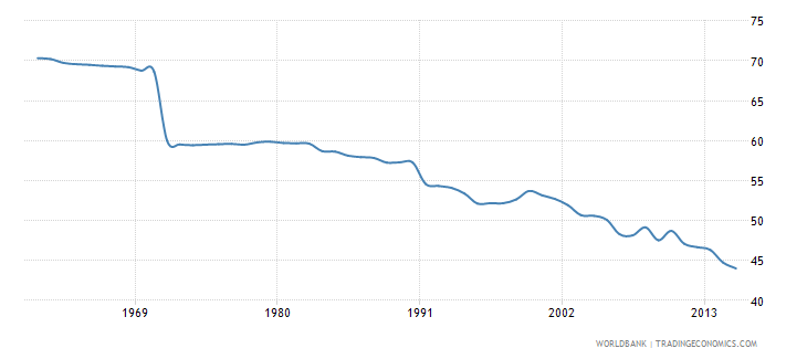
This chart shows the decline in agricultural land in Italy, plotted in percentage of land area.

Archaeological features, such as buildings or earthworks, may be completely buried beneath the ground. However, their interaction with surface processes may enable them to be seen, particularly in images acquired from above.
In dry periods, for example, vegetation growing at the surface may be forced to place deeper roots into the ground to find moisture. If a buried wall hinders root growth, the overlying vegetation will wilt. Conversely, a buried earthwork, such as an ancient moat or canal, may contain soil with increased moisture content. The roots of vegetation overlying the buried earthwork may therefore grow more abundantly:
This differential vegetation growth can sometimes be seen in images acquired from above.
Even if there is no vegetation growing above buried structures, in some cases, traces of such structures can be brought to the surface by ploughing activity:
These conditions that cause buried archaeological features to be visible at the surface may not last long. Differential vegetation growth caused by buried structures may appear in dry periods, but following rainfall, vegetation under stress will recover, and traces of buried archaeology may disappear...
This work has been carried out by researchers based in the newly created Phi-Lab of the European Space Agency. The two projects have been published in the web-based service Crowdcrafting, which uses the PYBOSSA Open Source framework for crowdsourcing.
Over the UK, advantage is taken of the exceptionally dry summer of 2018, when many cropmarks were revealed. Here users of the crowdsourcing app would view time series of Sentinel-2 imagery over a large part of the south of England to detect cropmarks through their evolution over the summer period.
Over Italy, users view single images of very high resolution oblique air photos available in Bing Maps, to detect the abundant crop marks in the rapidly disappearing countryside surrounding the city of Rome, up to a 25 kilometer radius from the city centre. Archaeological crop marks in the Lazio area are usually of ancient Roman origin. They tend to have clear geometric patterns, revealing the foundations of buildings. Roman roads can be distinguished as very straight lines of parched vegetation (overlying ancient paving stones), with strips of greener vegetation on either side, where ditches used to be.
There are python scripts to generate the task CSV files as well as to process the task runs (i.e. the answers to the tasks).
Use Python 3 and install the required python packages into a virtual environment. In linux based system:
cd scripts
python3 -m venv venv
source venv/bin/activate
pip3 install -r requirements.txt
The task generator scripts produce CSV files in which each row corresponds to a microtask. A CSV file is to be imported into a PyBossa project instance in order to create the tasks within that platform.
task_generator_bing_birdseye.py: Generates the microtask CSV file that utilizes Bing Maps bird's-eye imagery.task_generator_sentinel.py: Generates the microtask CSV file that utilizes Sentinel optical imagery.
The imagery URLs are generated based on the following inputs:
- Bounding box of the project's area of interest (latitude and longitude bounds).
- Imagery dimensions for a task (i.e. x and y lengths).
To run the Bing Maps bird's-eye task generator:
cd scripts
source venv/bin/activate
python3 task_generator_bing_birdseye.py
To run the Sentinel bird's-eye task generator:
cd scripts
source venv/bin/activate
python3 task_generator_sentinel.py
Completed tasks are called Task Runs. Task Runs can be downloaded from PyBossa as CSV files. The process_task_runs.py script processes those Task Run CSV files into results files, also in CSV. These result files group the task results based on following confidence thresholds:
- All tasks with 1 positive answer.
- All tasks with 2 positive answers.
- All tasks with at least 3 positive answers.
Note: This is currently only implemented for the Bing Maps bird's-eye imagery project.
To process the task runs, first download the latest \*_task_info_only.csv and \*_task_run.csv files from the PyBossa admin dashboard and save them into the project's task_runs directory before running the process_task_runs.py script:
cd scripts
source venv/bin/activate
python3 process_task_runs.py
The user interface that presents the task to the crowdsourced users. These are crowdsourcing project specific HTML files that are copied into PyBossa when creating the project.
task_presenter_bing_birdseye.html: Task Presenter for the PyBossa project that uses Bing Maps bird's-eye imagery.task_presenter_sentinel.html: Task Presenter for the PyBossa project that uses Sentinel optical imagery.
A simple HTML page to visually navigate through the Task results and filter them based on confidence thresholds.
Can be accessed here: https://esa-philab.github.io/buried-archaeology/task-run-navigator.html
Note: This is currently only implemented for the Bing Maps bird's-eye imagery project.


